


LOOOK, a Seattle-based mixed reality and development studio, can now peer into the future with their new geotechnical engineering visualization application for Microsoft HoloLens.
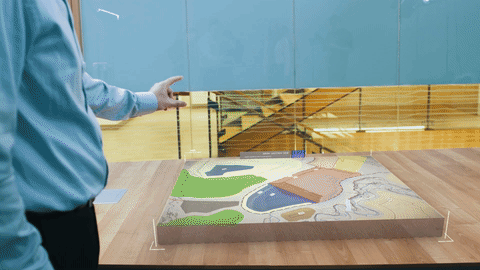
Developed in partnership with BCG Engineering, a geotechnical consulting firm based in Vancouver, Canada, the proof-of-concept application pulls data from various sources, including topographical maps, soil and rock profiles, and engineering plans, to render immersive 3D maps and landscape models of a mining site.
Developed by Loook in partnership with BGC Engineering, this HoloLens application can visualize 3D models of mining sites from engineering data.
"One of the biggest areas that we work in, and a constant challenge, is communicating complex earth science problems and solutions to our stakeholders, whether they are our informed clients, community members, or first nation groups," said Matt Lato, senior geotechnical engineer at BGC Engineering, in an interview with NextReality.
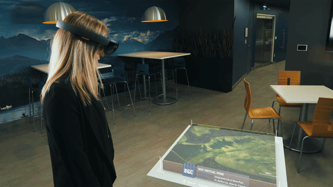
Using the engineering data and video game graphics, the application allows HoloLens users to walk the landscape and explore wetlands at a certain point on the reclaimed mine as it would look in a generic location in 2037. Eventually, users will be able to go to different viewpoints on the map.
All features are accurately represented to true scale, while the video game design adds trees, water, and light to make the visual representation feel real. While the 3D models demonstrate a generic location, they are accurate for terrain in the vicinity of Fort McMurray, Alberta, Canada.
Loook's application can show users what a reclaimed mine site will look like 20 years from now.
With 350 employees in the United States, Canada, and South America, the majority of BGC's work comes from the resource sector, including projects on open pit mining development and closure planning, and pipeline and transportation risk assessments.
Flat CAD drawings and maps remains the standard method for communicating findings and plans for these projects. Since these traditional tools also require a learned understanding to interpret and visualize, it can be difficult to relay this information to an audience of laypeople.
Upon the HoloLens and LOOOK's portfolio of work, BGC saw an opportunity to improve communication with audiences of varying technical background through augmented reality technology.
I can show you a million 2D drawings, but you'll never understand it as clearly as if I show you the same information in 3D using HoloLens. This has the potential to revolutionize how we communicate on a day-to-day basis.
After defining use-case scenarios and a narrowed down focus, the two companies solidified the vision for the application during a week-long envisioning workshop in September 2016. This resulted in storyboards of the visualization application for LOOOK to develop. A week later, LOOOK came back with a project proposal and schedule, which was approved and then developed in fairly quick timeframe.
BGC and LOOOK presented the completed proof of concept in December 2016 during the International Oil Sands Tailings Conference in Lake Louise, Alberta, Canada. The application, a semi-finalist in the #DisruptMining competition held on March 5 in Toronto, was announced by the firms via a press release and video in February.
While margins for geotechnical engineering are often slim, BGC were not concerned with making the investment, as the tool improves problem solving and avoids the cost overruns that can result from decision-making delays and poor communication.
It is essential that everyone is able to see and understand what we are doing. Project delays caused by miscommunication can cost our clients hundreds of millions of dollars.
The application exists today mainly as a proof of concept, though BGC is exploring the possibility of applying the technology to other projects in the future to show clients what is possible.
"It's a bit premature to talk about it, but we are planning to make it a real tool that will be used by other industries, not just mining, but forestry and agriculture. The idea is to really be able to provide a tool to people who are dealing with 3D points of data and give them a way to visualize that in HoloLens," said Sebastien Motte, cofounder and CEO of LOOOK, in an interview with NextReality.
Launched last April, LOOOK draws talent from Microsoft with experience working on HoloLens. Motte led the Xbox first-party business development team for 12 years. John Howard, cofounder and creative director at LOOOK, worked on HoloLens projects in partnership with NASA, AutoDesk, and Trimble.
What other industries could use this tool to visualize landscapes? Tell us your thoughts in the comments section below.
- Follow NextReality on Facebook, Twitter, and YouTube
- Follow WonderHowTo on Facebook, Twitter, Pinterest, and Google+
Cover image via LOOOK/YouTube


Comments
Be the first, drop a comment!